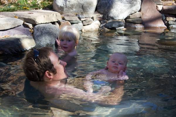
Families are very welcome here! And children under age 16 are always admitted for free. OLT preserves a world full of magic and discovery for children of all ages. Those who find clothing uncomfortable and restrictive are free to be themselves, au naturel. Adults here tend to be kind and playful, often regressing to their own childhood as they relax and notice the amazing world around them.
Note: Children must always be attended by their parent or guardian and respectful of other guests and the sensitive spaces we share here.
.jpg "Naked Cowboy")
.jpg "Family enjoying Soaking Pond")
.jpg "Family playing in the kid's pool")
.jpg "Discovering magic in nature")
.jpg "Kids Science Camp")
Well-behaved pets are invited to accompany their owners to OLT. We love animals and many staff have pets among their own family. However, we strongly urge pet owners to visit first without their pet to recognize how sensitive and alive this space is. Owners are held fully responsible for the behavior of their pets and risk fines and restrictions if left unattended or unleashed. This helps avoid disturbing the peaceful environment with potential aggression, territory, and abandonment issues that are common, especially among dogs.
No pets in any of the pools
First-time visitors are discouraged from bringing pets until they've first familiarized themselves with the space and wildlife here.
We have a limit of two pets per reservation. Please confirm if space is available for your pet when you make a reservation. A per visit fee will be charged for each pet. If appropriate, you may be asked to leave immediately and may not be allowed to return with your pet. If uncertain, please consider alternative arrangements for your pets.
Rates and Reservations with pet fees
Pet policies, Terms of Admission
.jpg "Winnie.... the perfect dog!")
-2.jpg "Winnie.... the perfect dog!")
-3.jpg "Winnie.... the perfect dog!")
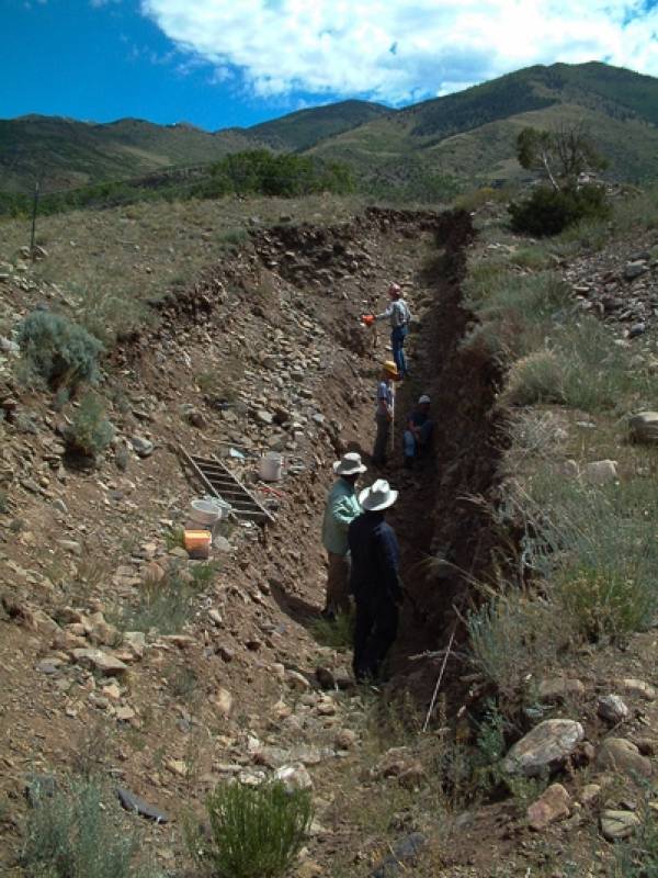
Valley View’s water rises along the Sangre de Cristo Fault (SCFZ), a planar geologic fracture across which the Sangre de Cristo range has been uplifted as much as 16,000 feet relative to the San Luis Valley. The SCFZ is Colorado’s most active fault, having displaced moraine deposits of the latest Pleistocene ice age as much as 6 meters vertically in 2 large prehistoric earthquakes of about magnitude 7 (but that’s another story...).
Bedrock in the fault zone has been crushed and rotated by this slippage, creating a near-vertical zone of interconnected void spaces that water can flow through. The fault zone is generally more permeable than the adjacent wall rocks, so it intercepts and diverts lateral deep groundwater flow from the mountains to the valley. This warm water then rises up the fault zone and emerges at Valley View. The springs are probably localized at this spot because an east-west fault in the mountains intersects the north-south Sangre de Cristo Fault, creating a small but severely crushed intersection zone.
.jpg "Exposed Fault Scarp at OLT")
.jpg "Dr. Rocks Exploring the Fault Scarp")
.jpg "Illustrating the Dramatic Villa Grove Fault Line")
.jpg "Wild Plants Growing in a Straight Line")
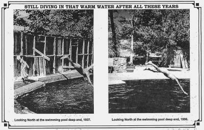
The spring flow is made of 2 water components: (1) deeper, warmer groundwater that intersected the fault zone at depth, got heated, and then rose up in the fault zone (geothermal water), and (2) shallow, cooler water from infiltrating rain and snowmelt (meteoric water). The flow volume of deep geothermal water is essentially constant through the year, but an influx of cooler meteoric water occurs from spring snowmelt in March to May of each year. At that time of year, the springs flow with the least volume but the entire flow is cooled by the larger component of cool meteoric water. Possibly the cooler water reduces the ability of the deeper, warmer water to rise. This effect is most pronounced at the top springs, which catches the most mountain runoff, and is less at the lower springs. Conversely, in late summer through mid-winter there is essentially no meteoric infiltration on the mountain, so the spring flow is increased in volume, but it’s hotter because it’s almost totally composed of deep circulating water. This year, the drought has caused water flow to drop to about 65% of the long-term average with no return to normal flow so far. However there has been no measurement of temperature above the normal 99 degrees at the top springs. Other dry spells have produced top springs temperatures of over 106 degrees. Clearly, further research is needed. Some poor geologist may have to do this, by soaking in all the pools repeatedly. Yes, it's a tough job........
James P. McCalpin, Former Director, OLT
President, GEO-HAZ Consulting, Inc.
Director, Crestone Science Center
Research Assoc. Prof., Utah State University
P.O. Box 837
600 East Galena Ave.
Crestone, CO 81131 USA
phone 719-256-5227
Fax 719-256-5228
OLT is located in Saguache County, the Northern-most county in the SLV. Environmental advocacy is just one of the ways the Orient Land Trust supports the northern San Luis Valley. Tourism and education bring interest, energy, and revenue back into the Valley.
The adjacent Rio Grande National Forest and Sangre de Cristo Wilderness Area provides abundant opportunities for hiking and mountain climbing.
USDA History and Culture Links
Saguache County's past and present are as diverse as the great expanse that it occupies. Its natural geography made it a crossroads and settlement area for Ute and other Natives Tribes, explorers, fur trappers, miners and settlers. Saguache County was officially founded in 1866. In the Ute language the word Saguache means, "water at the blue earth."
By the 1870's, gold, silver and other large mineral deposits were discovered in the Sangre de Cristo and San Juan Mountain ranges. By the 1930's, mining and railways moved out and farming and ranching moved in. Saguache County continues its agricultural heritage today despite the challenges of receiving less than 7 inches of precipitation per year. This 3,170 square mile high altitude desert is home to more than 75% public land, including national forests, wildlife areas and refuges, national park and wilderness areas.
The County is comprised of the Towns of Saguache, Moffat, Center, Crestone, Bonanza and the unincorporated areas of Sargents, La Garita and Villa Grove.
In 2010, Saguache County's population numbered approximately 7000 people, with 53% living in the unincorporated areas. This represents full-time residents, however, many people are drawn to the County for seasonal activities increasing the population and the need for services. Population has grown about 11% since the year 2000. The largest minority groups include Hispanic/Latino, which represent about 34% of the population.
Statistically, Saguache County has been one of the most economically challenged counties in Colorado for decades. Economic growth is the concern Saguache County residents express most in planning processes. There is a clear need for activities that can ensure economic stability for residents while remaining consistent with the core community values of preserving open space and wildlife habitat.
The local economy is based on the traditional industries of ranching and farming that now struggle to provide a sustainable economic engine. The following industries rank in order of income importance to Saguache County: Agriculture (38.1%); Retirees (15.2%); Commuters (10.5%); Public Assistance (8.1%); Tourism (7%); Indirect (6.9%); Government (5.7%); and Manufacturing (2.8%).
In the year 2000, the median household price was $73,900 and median household income (MHI) was $25,495. While income increased 18.4%, the cost of housing increased nearly 90%. This means that home ownership is less affordable for full-time residents now than it was just a few years ago. This is reflected by the estimated per capita income of $18,284 as compared to $29,133 for the State of Colorado. Saguache County taxes, land-values and costs of goods and services remain some of the lowest you can find in this and surrounding states.
Education
Saguache County is home to three school districts: Center Consolidated D26JT, Mountain Valley Consolidated RE1 and Moffat Consolidated D2 that includes the Crestone Charter School. 580, 120 and 206 students were enrolled respectively during the 2010-2011 school year. Each district has experienced enrollment decline over the past 10 years and continue to face increasing challenges due to state education budget cuts. Center and Mountain Valley Schools have been identified by the Colorado Department of Education as districts in need of Priority Improvement Plans. It is not uncommon for Saguache County families to send children to larger school districts as far as Alamosa or Salida, both more than 50 miles away.
Other Resources
www.saguachecounty.net
www.choosesaguache.com
The adjacent Rio Grande National Forest and Sangre de Cristo Wilderness Area provides abundant opportunities for hiking and mountain climbing.
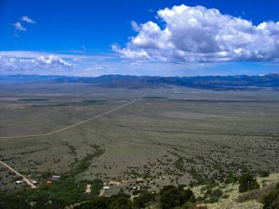
Founded in 1882, the Town of Villa Grove sits towards the northeastern corner of the county on US 285, 15 miles south of Poncha Pass. It is an unincorporated town that has a resident population of approximately 30 people. In the past, it was a vital supply town for miners and ranchers. Today, it provides services for travelers and local residents alike. Villa Grove has a Post Office, Town Park, one year-round café/general store, motel, liquor store, pottery studio-gallery, and other businesses that serve the area's needs.
Bonanza, incorporated in 1880, is a 'sister town' to Villa Grove and is located at the end of County Road LL56 in the Rio Grande National Forest, approximately 15 miles west of US 285. Mining was predominant in the entire region and ranching grew with the influx of families working in the area. During its heyday in the 1880's, the town had a population of 1500 and was renowned for its 36 saloons and seven dance halls. Remnants of mine structures can still be seen around the Town. Today, it has few full-time residents, and the Town Board has petitioned to become unincorporated. Bonanza serves primarily as a tourist attraction and National Forest access point.
The Town of Saguache is located at the junctions of US 285 and CO 114 in the northwestern part of the San Luis Valley and has a population of approximately 500 people. It is surrounded by ranching, agricultural and public lands and has a history steeped in sheep, cattle, grain, grass hay, and alfalfa production. It has been a gateway to the San Juan Mountains for centuries and a supply hub for travelers past and present.
Saguache is also the County seat. It houses local and county government buildings including the County's Social and Public Health services, State Registered Historic Courthouse with administrative offices, law enforcement offices and jail, road and bridge offices, pre-K through 12th grade school, Public Library, veteran's office and BLM and National Forest offices. The Town also has a large park with a community center building built in the 1930's with WPA funding.
The Town of Saguache is situated along a part of the Old Spanish Trail which follows CO northwest towards Cochetopa pass. There are many registered historic sites in and around the Town including the Saguache Flour Mill which is located approximately one mile outside of town and located within the Town are: the Saguache School and Jail buildings, which house the Saguache County Museum; St. Agnes Catholic Church, and Dunn's Block/Means & Ashley Mercantile Company. As part of an ongoing revitalization process, the downtown's Fourth Street business district was listed on Colorado Preservation, Inc.'s Most Endangered Places 2009 List.
Business that are located in and around Saguache include gas stations, grocery store/deli, liquor store, restaurants, hair salons, movie theatre, bookstore, lumber mill, lumber and hardware yard, day care center, abstract and title office, bank, newspaper, motels, several churches, organic farms, and auto mechanics.
The town of Crestone is located 12 miles east of CO 17 on County Road T along the base of the Sangre de Cristo Mountains at the eastern edge of the county. Crestone was incorporated in November of 1880. The current population is approximately 130 people. Mining and ranching fueled the early economy of the town and surrounding area. Presently, it is a destination for summer vacationers, hikers, climbers, retirees, and sacred-based tourism. The town has several businesses which also serve the near-by Baca Grande subdivision. These include the Crestone Eagle newspaper, a branch of Aventa Credit Union, several churches and spiritual centers, the Crestone Merchantile grocery store and hardware, Crestone Artisans Gallery, gift, and thrift stores, cafés and tea house, and liquor store. Built in 1880, the Crestone School, (now the community building), is a Nationally Registered Historic site. The area is also served by the Crestone-Baca Library, a fieldwork office of Colorado College, and the K – 12th grade Crestone Charter School.
Moffat was incorporated in the late 1890's to serve as a major hub for the Denver and Rio Grande narrow-gauge railroad line, which moved agricultural products and mining ore. It is located on CO 17 approximately 15 miles north of Hooper and 17 miles south of Villa Grove. In its peak, the population was in the thousands. From then, it dwindled to about 120 and has remained the same since the early 1920's. The Town has a Post Office, pre-K through 12th grade school and several businesses including a coffeehouse-gallery, health food cooperative, café'-bar, and health care clinic. The First Baptist Church of Moffat is a Nationally Registered Historic site. Moffat is surrounded by agricultural lands and has large areas of them within its town limits.
First settled by the Spanish in the early to mid 1800's, La Garita, meaning sentinel or lookout, is located approximately 6 miles west of US 285 on County Road G. It sits at the gateway to the La Garita Wilderness Area and the San Juan Range, and is surrounded by agricultural lands.
There is a local store which has a café and serves as an information center for local attractions such as the Penitente Canyon Recreation area, a premier rock climbing destination, La Garita Natural Arch and La Ventana (The Window) and several significant cultural sites, including two Nationally Registered Historic ones: the Capilla de San Juan Bautista Church and the Carnero Creek Pictographs.
Center is located on CO 112, approximately 13 miles west of CO 17 and 2 miles east of US 285. It is an incorporated town that has most of its boundaries in Saguache County and a portion in Rio Grande County located to the south. It has the largest population of the towns in Saguache County with approximately 2,389 residents. Large-scale agriculture is the main economic industry. Many farms, including some of the country's largest in organic production, surround the town and several agricultural processing plants are located here. Center has a commercial district with many shops and services, including a grocery store, gas stations, Town Hall and jail, Post Office, restaurants, hardware and feed stores, two banks, a credit union, and branches of the County's Public Health and Department of Social Services offices. Center has a pre-K through 12th grade school. There is a National Resource Conservation Services (NRCS) office which contains a Farm Service Agency and Conservation District office. A railroad spur called the "peavine" is located on the east side of Center and runs southwest to the Town of Monte Vista.
Settled in the late 1880's, Sargents is an unincorporated community located at the north-central boundary of the county and on US 50 at the west base of Monarch Pass. It served as a major refueling and maintenance stop for the Denver and Rio Grande Railroad until demand for the railroad declined. By the 1950's Sargents had all but disappeared. The old water tank and remains of coal chutes are still visible and the school house is on the Colorado Historic Register.
Today, there is a Post Office and local store with café, rental cabins, gasoline, towing, and car service. The community has approximately 25 full-time residents in an area with large ranches and 35-acre home sites.
Note from Scott-The City of Salida is the county seat and most populous city of Chaffee County, Colorado, United States.[5] The population is around 5236 people.
Founded in 1880, Salida was originally a railroad town and was a significant link in the Denver and Rio Grande Western Railroad. After World War II the railroad began pulling back its operations in Salida. Many residents in the 1950s, 1960s, and 1970s worked either in local ranching operations or commuted north to Leadville to work at the Climax Molybdenum Company. Today, the most prominent business in Salida is tourism, consisting of skiing at Monarch ski area, whitewater rafting, kayaking and outfitting, particularly on the Arkansas River. Salida is home to the annual FIBArk kayak race, one of the oldest whitewater races in North America.
Salida’s charming downtown area, the largest historical downtown district in Colorado, is home to blocks of Victorian buildings with fantastic restaurants, inspiring galleries, tempting boutiques, outdoor sports stores, and an array of shops for kitchen, kids, books, knitters and quilters. It’s a great place to stock up or find a unique gift to take home.
Salida hosts an impressive calendar of performing arts and special events including great theater productions, a fantastic array of music at coffee shops, taverns, Salida High School’s John Held Auditorium, or the Salida Steamplant Performing Arts Center and Conference Center.
From Salida Chamber of Commerce Website and Wikipedia
Note from Scott- The city of Alamosa is the county seat and the most populous city of Alamosa County, Colorado, United States. The population is 8,780. The city is the commercial center of the San Luis Valley in south-central Colorado.
Prior to 1868 the Capote (Kapota) band of Ute Indians lived in the valley.[11] The Utes made a treaty of peace with the United States in 1849 shortly after the Mexican War. Shortly thereafter settlers from New Mexico established several small settlements in what is now Colorado and in 1868 the Utes were removed to a reservation in western Colorado. They continued to play a role in Saguache in the northwestern corner of the valley from the Los Pinos Agency to the west of Saguache until they lost their expansive reservation as the result of the Meeker massacre in 1879.[12]
The area was administered as part of the Spanish, later Mexican, province of Nuevo Mexico until the area was ceded to the United States in 1848 after the Mexican-American war in the Treaty of Guadalupe Hidalgo.
Alamosa was established in May 1878 by the Denver and Rio Grande Railroad and quickly became an important rail center. The railroad had an extensive construction, repair and shipping facility in Alamosa for many years and headquartered its remaining narrow gauge service here with trackage reaching many points throughout southwest Colorado and northern New Mexico. Alamosa is now a notable tourist town with many nearby attractions, including the Great Sand Dunes National Park and Preserve and Colorado Gators Reptile Park. The town hosts "SummerFest on the Rio" which occurs the first weekend in June and the Early Iron car show over the Labor Day weekend. The city takes its name from the Spanish adjective Alamosa, meaning "of cottonwood", for the cottonwood forests which grow along the Rio Grande and throughout town
Agriculture in the San Luis Valley is generally concentrated around the Colorado towns of Alamosa, Monte Vista and Center. Principal crops include potatoes, head lettuce and barley. The barley grown here is the main supplier for Coors beer company. In 1982, quinoa was successfully grown for the first time outside of South America in the San Luis Valley of Colorado,[15] and commercial growth has occurred since 1987.[16] Less favored areas with a shorter growing season and less access to water rights tend to be devoted to alfalfa and grazing. Broad areas, especially in Saguache County, Colorado have a high water table or are even flooded part of the year. Uncultivated land is often covered with "chico", low brush such as rabbitbrush, greasewood and other woody species. Cropland is typically irrigated with large (1/4-mile radius) center-pivot irrigation systems, and a common feature of the Rio Grande Delta area where the Rio Grande enters the valley are large piles of potato-sized rocks screened from the soil.
The area supports a wide variety of wildlife. Sandhill cranes migrate through the valley every spring and fall. The Monte Vista Crane Festival takes place in March, centering on the wildlife refuge located six miles (10 km) south of town. Occasionally, a whooping crane can be spotted among the thousands of grey sandhills. The valley is a flyway for many migrating birds including avocets, bald eagles, goldfinches, and a plethora of hawk varieties.
There's nothing else like it. The tallest dunes in North America are the centerpiece in a diverse landscape of grasslands, wetlands, conifer and aspen forests, alpine lakes, and tundra. Experience this diversity through hiking, sand sledding, splashing in Medano Creek, wildlife watching, and more!
What are gators doing in the valley? Well it started with the Rocky Mountain Tilapia fish
The clear night skies of the valley bring opportunities for sights astronomically known and unknown and mysterious. Consider a rendezvous at the UFO Watchtower outside of Hooper, CO.
OLT is surrounded by public lands composed of the Rio Grande National Forest and the San Luis Valley Bureau of Land Management. The Rio Grande National Forest is approximately 1.86 million acres in size and is located in the mountains surrounding the San Luis Valley. The SLV Bureau of Land Management is composed of almost 600,000 acres of land in the foothills and on the Valley floor.
Bureau of Land Management
US Forest Service
San Luis Valley Public Land Center
Villa Grove- Villa Grove Trade 8am-4pm daily (www.villagrovetrade.com), The Steel Horse (opening May 4, 2013)
Saguache- The Oasis, 4th Street Diner and Bakery, Utopia Bar & Cafe in the Ute Theatre, Liquor Store (name?), Saguache Town Market grocery and gas, First Stop gas station
Crestone- Bliss Cafe, Farm Table, Desert Sage, Shambala Cafe, Elephant Cloud Organi, Secret Garden, Crestone Spririts Liqour Store and Crestone Mercantile grocery store
Moffat- S&S Station bar & grill, Mirage Trading Post Espresso and Gallery, Sangre de Cristo Trading Post grocery/supply/buffet lunch by donation
Monarch Mountain (www.skimonarch.com), Wolf Creek Ski Resort (www.wolfcreekski.com), Toas Ski Valley (www.skitaos.org)
San Luis Valley Campground (Private)
North Crestone Campground (Public)
The Inn at Villa Grove (Villa Grove Trade)
Hillside Motel, Saguache
Sagebrush Inn, Crestone
San Luis Valley Campground
in Salida on Highway 50 by the Salida Museum
Visit OLT’s modest museum or stop by Saguache’s Museum, just a 20 minute drive.
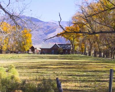
OLT’s historic Everson Ranch, is a 150-year old ranch that is currently being renovated within its historical facades to create an educational and living agricultural facility showcasing sustainable agricultural processes.
In 2004, OLT [[raised donations]] purchased the neighboring 760-acre historic Everson Ranch from developers to protect the open space and agricultural heritage forever. OLT has since purchased several other parcels to secure the view scape from small scale development and securing it for agriculture.
.jpg "School Teacher in the Snow")
.jpg "Orient School Teacher and Friend at Valley View, 1926")
.jpg "Valley View Engagement, 1927")
.jpg "Family Tour of the Orient Mine")
.jpg "Family Tour of the Orient Mine")
.jpg "Miner and his Car")
.jpg "Couple of the Orient Mine")
.jpg "Girl Playing Banjo")
.jpg "Girl at the Orient Mine")
.jpg "Girls on Bridge at Orient")
.jpg "Orient Children Dressed as Miners for a Play, 1928")
.jpg "Orient Children Performing as Hawaiians, 1928")
Those of us that live in the urban areas and bedroom communities of Colorado may be unaware of the ranchers and cowboys who work in rural areas producing meat, milk, fiber, and other animal by-products. While some are aware of mass-producing factory farms, these citizens may lose the opportunity to appreciate the ranching heritage of rural Colorado.
How many Coloradoans know that lambing and calving entail 24-hour watches in sub-zero temperatures in order to ensure the warming and survival of the new offspring? How many of us recognize the losses associated with auctioning off cattle when there is not enough water to grow the hay needed to feed them? The art of ranching and the way of life it entails is not commonly understood in the urbanized world of today. What threads of knowledge, tradition and meaning have kept ranching families rooted to their land and life style for generations despite the hardships? There is joy, harmony, relevance, and authenticity in this way of life and it is communicated in the arts and activities of our Valley residents.
At the turn of the century, between 1800-1900, the San Luis Valley began to grow. Located at its north end in Saguache County, were mining boom towns like Bonanza, Orient, Crestone and Liberty, and the shipping towns which serviced them, Moffat and Villa Grove. Ranching flourished trying to feed a growing young nation. Moffat, at the center of all this commerce, had a train station, huge stock yards, and narrow-gage lines from the mines of the Sangre de Cristos. Once recognized as the "queen city" of the valley, and considered for the site of Colorado's state capital, Moffat was home to 2,500 residents with passenger trains running twice a day. With the advent of the trucking industry, and experiencing a devastating fire, Moffat downsized and became an agricultural town producing cattle, hay and turning out young ranchers who attended the Moffat Consolidated Schools.
Today Moffat continues its agricultural heritage with many of the original families still ranching and farming. Moffat's central location in northern Saguache County houses the Moffat Family Health Clinic, and Moffat Consolidated Schools serving Crestone, the Baca, and northern Saguache County. Many businesses thrive in Moffat's small town atmosphere with a convenience store, coffee shop, an art gallery, trading post, excavation company, bed and breakfast and a self-storage facility.
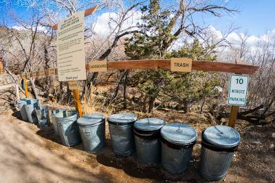
OLT promotes and models the "three Rs" of sustainable lifestyles - Recycle, Reduce, Reuse. We encourage visitors to include these ideas in their activities while visiting and after returning home. Use your imagination to think of new ways to implement the three Rs, because everything you do makes a difference.
OLT provides collection points for recycling of glass, aluminum, plastic. However, the recycling, and the garbage, must be hauled by OLT nearly 100 miles for disposal. Because this long drive uses a significant amount of fuel, OLT suggests that visitors implement "pack it in, pack it out" principles for their recycling and trash if they have curbside pickup service at home. This helps reduce the overall impact on our planet. If you can't take it home, OLT will be happy to help recycle the items you use during your stay.
[use showers to collect sunblock, etc]
In the interests of sustainability operating entirely “off-grid”, Valley View’s waste waters are treated onsite. Organic nutrients carried by the water return to the ecological cycle where they support a wide range of plants and animals.
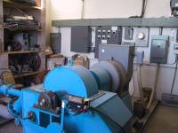
Nearly all our cabins and buildings are heated with gentle geothermal water. The spring water slowly passes through the floor, radiating a comfortable and constant warmth like no other. The water then passes on to support...
Every modern comfort our visitors enjoy, from our sauna to our cooking facilities, are entirely “off-grid”.
Most are powered using a highly efficient hydroelectric power plant. The same spring waters our guests soak in also warms our cabins, nourishes the plants and wildlife, and generates a moderate amount of electrical power. We dispense this limited electricity as wisely as possible, off-loading these demands as need be to compensate for drought seasons.
The hot springs facility operates entirely off-grid and is profoundly affected by precipitation and visitor usage. As part of our educational mission, we've shared this and other natural resources with 27,000 visitors annually for decades. All energy conserved by guests is directed through our governor and into extra hot water for the soaking they so enjoy. Visitor's interest is further developed with guided Hydro tours, active research, and educational campaigns. These direct connections have inspired sustainable living practices for generations forming a wide-spread community of tourists, locals, and environmental enthusiasts. We've cultivated long-standing partnerships with schools, government, local, and environmental organizations including an engineering school who's freshman class created sustainable energy designs for our newest property, a historic ranch and campus. Simply put, the possibilities are tremendous!
Sustainable Energy Tour
Interested visitors should inquire about our in-depth geothermal and hydroelectric tours. Hosts show them the entire cycle, visiting the springs, collection box, down to the hydroelectric power plant, following the current back up to the governor, and finally to experience the benefits first hand.
Astronomy Hosts share the science and wonder of the night sky with visitors. With our 8” telescope, guests can spot distant galaxies, fascinating stars, as well the rings and moons surrounding nearby planets.
Heavens Above, Site 1792105 (OLT) - astronomy and satellite events, localized to Valley View Hot Springs
Space Weather - meteor showers, solar weather, and aurora sightings
Year round, our overnight guests can soak comfortably under the stars all night. All spaces remain open through the night. We maintain minimal artificial light and recommend having a flashlight ready well before dusk. Most visitors are surprised how comfortably they can soak for hours. Do please keep a low voice out of respect for others sleeping in nearby tents and cabins.

Valley View Hot Springs is well known for its natural setting, kind culture, and a tradition of open air naturism. Clothing is altogether optional throughout the property. Nudity is not inherently indecent, suggestive, nor demeaning. It’s simply a natural, healthy, and comfortable choice.
“Never before did I get so close to Nature; never before did she come so close to me... Nature was naked, and I was also... Sweet, sane, still Nakedness in Nature! - ah if poor, sick, prurient humanity in cities might really know you once more! Is not nakedness indecent? No, not inherently. It is your thought, your sophistication, your fear, your respectability, that is indecent. There come moods when these clothes of ours are not only too irksome to wear, but are themselves indecent.
Walt Whitman, 19th century American poet
New to naturism? No worries...
There's nothin' to it ...really.
Few people experience social nudity outside a locker room or home, if that. At Valley View, soakers often find nudity preferable especially as they emerge from the warm water into the cool, dry air. Hikers visiting the Orient Mine appreciate the freedom to shed off sweaty clothes and feel the breeze. Many feel less judged, enjoying great conversations with diverse people, some of whom they may never have met otherwise. Put simply, nudity is natural.
 Naturism at OLT
(printable guide for sharing, Adobe PDF format)
“Naturism is the practice of clothing optional communal nudity in a non-erotic setting, with a commitment to inclusiveness and diversity, and without discrimination based on race, age, gender, sexual orientation, religion, national or ethnic origin, lifestyle or socio-economic background. The purpose of preserving the naturist culture is to encourage body acceptance, self-respect, respect for others, and caring for the environment. The property provides a pristine, rustic and peaceful setting in which to enjoy the benefits of a naturist lifestyle including feelings of physical, spiritual, and psychological well-being, as well as a sense of freedom and relaxation.”
as outlined by OLT's Founders
Personal Choice: Clothing is a personal choice in all areas and at all times. Nudity is neither prohibited nor expected.
Social Decency: Aside from public nudity, social norms are no different. Naturists are empowered, maintaining strong personal boundaries regardless of clothes or setting. Leering, harassing, sexual, and suggestive behavior is no more appropriate here than any public park, campground, or pool. Hugging and affection are common among friends. If anything, naturists tend to be especially courteous, accepting, and considerate of others.
Non-erotic Setting: Naturism is not opposed to sex, but makes a clear distinction between sex and mere nudity. Sexual behavior is considered private, for consenting adults in their own private space. With our peacefully platonic open space, self-control is normal and natural.
Males and Females: Men concerned they may become aroused can simply don a towel, turn over, or take a dip in the pool. Menstruation is a natural part of every woman’s life. Some use tampons while others prefer pads with shorts or bathing bottoms.
Friendly Help: If ever unsure, just ask! We're happy to answer any questions or concerns, however sensitive they may be.
Relaxing: Unlike stripping or streaking, being naked here is practical, not provocative. Instead of a thrill, naturists seek a simple awareness and acceptance of their own bodies and those of others.
Privacy from Cameras: Camera devices including cell phones are not to be used where others are in view. Photographing the landscape and wildlife is encouraged, just so long as others aren’t included without their consent.
Children of All Ages: Kids naturally prefer nudity. We welcome families as well as couples and singles from all walks of life, religions, and lifestyles. We do require
swim diapers until toilet trained. And like anywhere else, parents are responsible for their children and asked to remain with them at all times.
Every Body: When it comes to body variations, naturists are among the most accepting people you'll ever meet. We accept those with tattoos, jewelry, piercings, surgical alterations, and medical accessories. Diversity is every bit as important to our community as it is to our eco-system.
Communal Space: We have no private nor segregated pools. All guests share unisex bathrooms with private stalls and showers. A variety of private cabins and rooms may be reserved.
Healthy Facilities: Our professional staff clean the pool each week or so, the rooms before each visit, and the communal bathrooms and kitchens daily. The fresh spring water and natural ponds flow fast and clean, all without the use of chemical disinfectants. Nudity is always optional in all spaces and not deemed unhygienic by us nor the Health Department. Although sharing bare seating poses less risk than common faucets or door knobs, some find sitting on towels most comfortable. We don’t judge. Certainly anyone with a rash or wound may prefer a barrier.
Remote Location: Our vast property is owned and managed by the Orient Land Trust to prevent overcrowding and development, all as a nonprofit public service. It is surrounded by miles of BLM public open-space providing a peaceful escape whether soaking, camping, or hiking.
Sunny Days and Dark Nights: At this altitude, sunscreen may be prudent although we ask guests to rinse off before entering the waters which we share not only with one another but also the birds, bats, fireflies, and threatened fish. Alternatively, a sunhat and sarong can offer great protection both in and out of the water. Flashlights and rugged shoes are recommended for the well-worn, but rocky trails between each pond.
It is generally agreed by naturist organizations that eroticism and blatant sexuality have no place in naturism and are, in fact, antithetical to its ideals.
.jpg "Au Naturel in Nature")
.jpg "Life-long Enjoyment")
.jpg "Napping on the Edge of the World")
.jpg "Lady sitting at edge of Waterfall Pond")
.jpg "Kids playing in the pool")
.jpg "Neil Seitz, co-founder at Apple Tree Pools")
![]() Join The Naturist Society to learn more about naturism at protected locations around the world. TNS members receive discounted admission at Valley View Hot Springs.
Join The Naturist Society to learn more about naturism at protected locations around the world. TNS members receive discounted admission at Valley View Hot Springs.
For the education, enjoyment, and well-being of current and future generations, Orient Land Trust:
promotes a positive clothing-optional experience at all properties including Valley View Hot Springs, Orient Mine and Everson Ranch;
preserves the viewshed, including land acquisition;
protects natural, wild, agricultural, and historic resources, in the northern San Luis Valley.